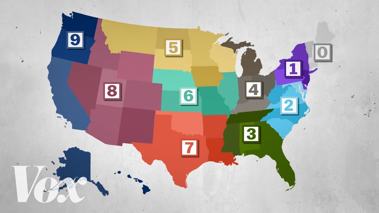
A ZIP code is not chosen at random; it is systematically assigned by the U.S. Postal Service (USPS) to help organize and route mail efficiently across the country. The system links each ZIP code to a specific mail‑delivery area and evolves as population, infrastructure, and delivery needs change. facts.usps
Who assigns ZIP codes and when they started
ZIP codes were introduced in 1963 under the Zone Improvement Plan (ZIP) to manage rapidly growing mail volumes and to support automated sorting. The USPS centrally assigns and maintains ZIP codes, reassigning or updating them as new neighborhoods, post offices, and delivery routes appear. en.wikipedia
How the five‑digit structure is built
The classic five‑digit ZIP code is designed so that the digits encode geography and processing hierarchy:
- The first digit corresponds to a broad region of the United States (roughly “0” for the East Coast and increasing to “9” for the West Coast). youtube
- The second and third digits identify a sectional center facility or larger regional hub that receives and routes mail for that area. zors
- The last two digits specify a particular post office or delivery zone within that region. britannica
This layered structure means that automated sorting machines can quickly narrow mail down from a national region to a local post office just by reading the ZIP digits. smarty
ZIP+4 and more granular assignments
In 1983, the USPS added the ZIP+4 system, which appends four extra digits to form a nine‑digit code (for example, 12345‑6789). These additional digits can represent a specific street, block, side of a building, or even a high‑volume customer such as a large corporation or apartment complex. facts.usps
New ZIP+4 codes are assigned as delivery patterns change, such as when a new industrial park, campus, or large residential complex opens and generates significant mail volume. This allows USPS and commercial shippers to sort mail down to very precise delivery segments, improving speed and accuracy. geoapify
Factors that influence ZIP code boundaries
ZIP codes are shaped by a mix of practical and logistical factors rather than strict city or political boundaries:
- Postal‑service efficiency: ZIP codes are drawn around actual delivery routes, post offices, and transportation nodes so that carriers can complete their routes in a single day. en.wikipedia
- Population and density: Rapidly growing suburbs or new developments may be split into new ZIP codes or have existing codes redrawn to balance mail volume per route. zors
- Business and institutional needs: Large businesses, universities, or government facilities with heavy mail traffic are often given their own ZIP or ZIP+4 codes for easier sorting. britannica
As a result, ZIP code boundaries can cross city or county lines, and some cities may contain multiple ZIP codes while others share codes across municipal borders. en.wikipedia
Why ZIP codes sometimes change
ZIP codes are periodically updated because mailing needs evolve. Common reasons include: geoapify
- Opening or closing post offices or distribution centers.
- Shifting population patterns or major new housing developments.
- Changes in delivery routes to reduce driver time or improve efficiency. smarty
When a ZIP code changes, residents and businesses are notified so address records can be updated, but the new code still reflects the same underlying sorting logic: region → sectional center → local delivery zone. facts.usps
References
- U.S. Postal Service, “Introduction of the ZIP Code” (U.S. Postal Facts) – explains ZIP‑code structure, regional digits, and the introduction of ZIP+4. facts.usps
- Encyclopædia Britannica, “ZIP Code – Postal Addressing, Delivery, Formatting” – overview of the ZIP system, its history, and role in mail sorting. britannica
- ZIP‑code and mailing‑address guides (Wikipedia, Smarty, and other technical‑/education‑oriented resources) describing how USPS assigns ZIP codes based on geography and delivery routes. smarty
- Data and mapping resources (Geoapify, ZIP‑code geolocation tools) illustrating how ZIP codes are updated and distributed across U.S. geography. cran.r-project
No approved comments yet.